Spiritual Architecture
land allotment in promised land- inheritance
stone builders rejected
leveling smoothing before foundation laid
military – road construction (path) wilderness, tribe encampment
SURVEYING or land surveying is the technique, profession, art and science of determining the terrestrial or three-dimensional positions of points and the distances and angles between them. A land surveying professional is called a land surveyor. These points are usually on the surface of the Earth, and they are often used to establish maps and boundaries for ownership, locations, such as building corners or the surface location of subsurface features, or other purposes required by government or civil law, such as property sales.
Surveying has been an element in the development of the human environment since the beginning of recorded history. The planning and execution of most forms of construction require it. It is also used in transport, communications, mapping, and the definition of legal boundaries for land ownership. It is an important tool for research in many other scientific disciplines.
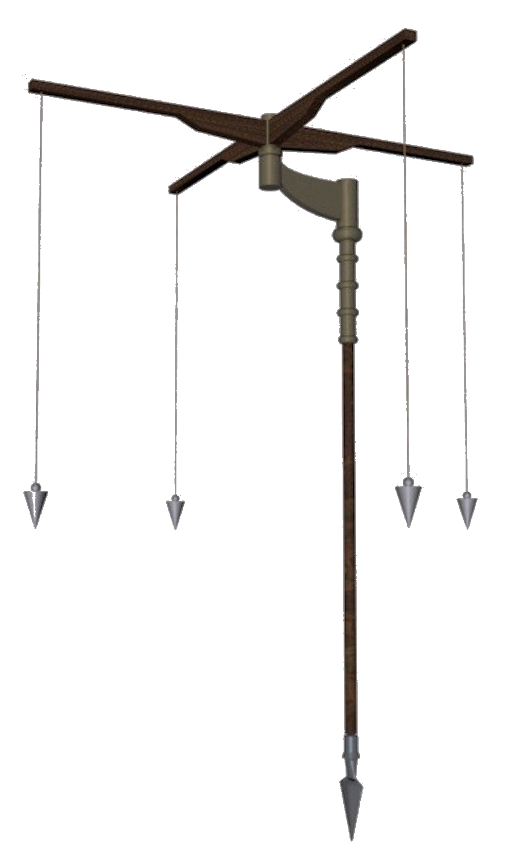
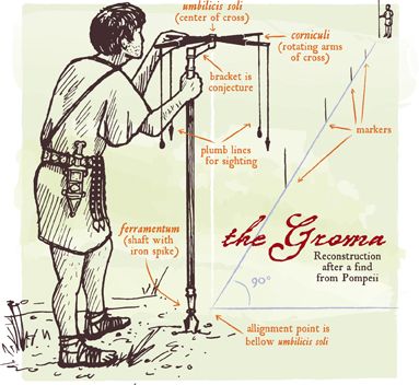
The GROMA or GRUMA was a Roman surveying instrument that built the Roman Empire. Simple to make and easy to carry, the groma1, or the surveyor’s cross as it is sometimes known, was the most widely-used Roman surveying tool. It comprised a vertical staff with horizontal cross-pieces mounted at right angles on a bracket. Each cross piece had a plumb line hanging vertically at each end. It was used to survey straight lines and right angles, thence squares or rectangles. They were stabilized on the high ground, and pointed in the direction it was going to be used. The helper would step back 100 steps and place a pole. The surveyor would tell him where to move the pole and the helper would set it down.[2]
Construction:
- The Upright: a one-and-a-half to two-metre-long pole. One end was metal-tipped to facilitate pushing it into the ground.
- The Rostro: an upwardly-curving right-angled extension, with an end fixed to the top of the upright via a swivel mount. This extension rotated horizontally through 360 degrees. The centre-point of the groma was attached horizontally to the upper vertical end of this extension via a swivel mounting. A plumb line was fixed beneath the groma’s mounting point to act as a third sighting point.
- The Groma: a simple cross of wood with arms of equal length. Each arm had a plumb line suspended from the end of it; each line was equal in length to the other three plumb lines.
- The Marker Peg: a peg positioned in the ground below the groma-mounting plumb line to mark the datum point.
How it worked:
When the groma was set up, generally on a high point or rise in the ground, the surveyor would turn the groma (the cross) so that one of the arms pointed in the direction that the road or construction was to take.
The surveyor would send out an assistant with some ranging poles; the assistant would stop after about 125 paces and hold a pole vertically with one end on the ground. The assistant was directed to move until the surveyor could see that the pole was in line with the three strings of the groma: the two on opposite arms of the cross (north and south) and the plumb line fixed to the groma end of the rostro. The process was repeated until the assistant had run out of poles, leaving a straight line of poles marking the course of the road. The surveyor would then move forward to the last pole, set up the groma again and send out his assistant with ranging poles to repeat the procedure.
If laying out a right-angle or corner of a building, the groma’s east and west plumb lines would be used.
Who used the groma:
- Gromatici: general building and road surveyors.
- Agrimensores: property and land-surveyors.
There were 4 main specialist types of Roman surveying;
- Military: Military surveyors laid out the roads throughout the Empire. They were also responsible for surveying the sites for marching, camps, forts and fortifications. These men also laid out the positions of Hadrian’s Wall and the Antoine Wall.
- Agricultural ; Agricultural surveyors were employed to supervise the allocation of farmland in the new colonies and to supervise the distribution of lands around the town in which the surveyors were based. Thanks to the groma, it is no wonder that early Roman field systems were noted for their square or rectangular shape.
- Architectural : Architectural surveyors laid out the municipal buildings and streets of the towns and cities.
- Services: Services surveyors, often working with architectural surveyors, were responsible for works such as water supply, and were controlled by the appropriate urban surveyor.
Surveying With A Groma:
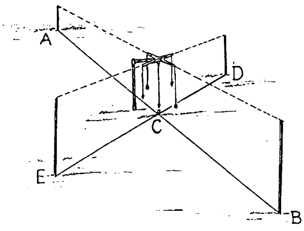
The roads were surveyed in the same way throughout the Roman world. It was impossible to lay out a perfectly straight road over many miles using the groma. This explains the course corrections (slight bends) that occur every few miles2. Groups of surveyors were used when a road was built between two distant points.
Firstly, the route was surveyed in sections marking out the high points. Then, after the first stage had been completed, the route was surveyed again between the high points to make it as straight as possible.
The same name (GROMA) was given to:
the center of a new town (heart/hinge/axis of the city)
from which the gromatici (surveyors) began to lay out cardo and decumanus grid, with a plough and a pair of oxen
- cardo : Cardo was the Latin name given to a north-south street in Ancient Roman cities and military camps as an integral component of city planning.
- The cardo maximus, or most often the cardo,[2] was the main or central north–south-oriented street.
- The cardo maximus was the “hinge” or axis of the city, derived from Greek καρδίᾱ, kardia — ‘heart‘ and as such was generally lined with shops and vendors, and served as a hub of economic life.
- In Roman city planning, a decumanus was an east–west-oriented road in a Roman city or castrum (military camp)
- the center of any new military camp
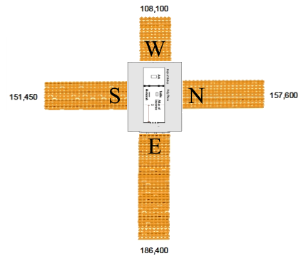
- i.e. the point from which was traced the regular grid by using the groma instrument
*** (my notes) plough, oxen, threshingfloor, temple, jerusalem, level, smooth,
in the wilderness there military tribal encampment formed the cross.
Stadia marks, also called stadia lines or stadia hairs, are CROSSHAIRS on the reticle of a theodolite or other surveying instrument that allow stadiametric rangefinding.
A level staff, also called levelling rod, is a graduated wooden or aluminium rod, used with a levelling instrument to determine the difference in height between points or heights of points above a vertical datum. It cannot be used without a leveling instrument.
When a boundary survey is performed by a licensed land surveyor, part of the surveying process is to find, locate, expose, and set property corners. There are several different types of survey monuments that adhere to state statute requirements. Let’s take a look at the most common ones:
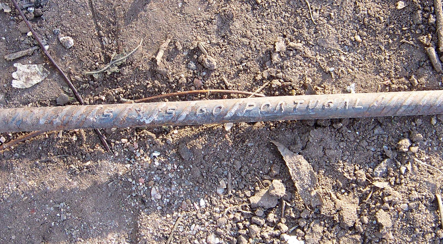
- Rebar:
- According to statute, this must be a minimum of 18” in length and ½” in diameter.
- It is a solid iron rod that is typically placed flush with the ground.
- When a survey monument is set by a surveyor, it must have a cap placed on the rebar which has the company name and license number stamped into it.
- Common colors of the caps are pink, orange and yellow
- Iron pipes:
- According to statutes this monument must be a minimum of 18” in length with a ¾” outside diameter.
- These monuments typically have a plastic cap set inside of the pipe with the same characteristics as mentioned for a rebar.
- Shafts of the Solomon’s Pillars 18 cubits long
- 1 cubit = 18″
- Cut crosses:
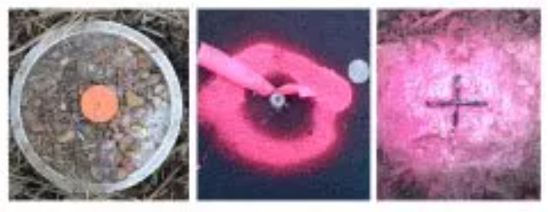
- This one is a little tricky.
- If the cross is set at the centerline of the street or located on a curb, there is a high probability that this is NOT an actual property corner.
- It is most likely a point on the projection of the property line.
- Crosses are typically etched into the concrete.
- The wood markers and pin flags that are commonly seen are not the property corner themselves.
- They are witness items to help you find the property corner that is located flush with the ground.
- So if the little boys next door pull the wood stakes to have a sword fight, all is not lost.
- Look for spray paint and hopefully you’ll find the survey monument that marks the property corner.
Revelation 2 : Church of Thyatira
24But I say to the rest of you in Thyatira, who do not hold to her teaching and have not learned the so-called deep things of Satan: I will place no further burden upon you. 25Nevertheless, hold fast to what you have until I come. 26And to the one who overcomes and continues in My work until the end, I will give authority over the nations. 27He will rule them with an iron scepter and shatter them like potterya —just as I have received authority from My Father. 28And I will give him the morning star. 29He who has an ear, let him hear what the Spirit says to the churches.’’
Revelation 12 : The Woman and the Dragon
1And a great sign appeared in heaven: a woman clothed in the sun, with the moon under her feet and a crown of twelve stars on her head. 2She was pregnant and crying out in the pain and agony of giving birth. 3Then another sign appeared in heaven: a huge red dragon with seven heads, ten horns, and seven royal crowns on his heads. 4His tail swept a third of the stars from the sky, tossing them to the earth. And the dragon stood before the woman who was about to give birth, ready to devour her child as soon as she gave birth. 5And she gave birth to a son, a male child, who will rule all the nations with an iron scepter.a And her child was caught up to God and to His throne. 6And the woman fled into the wilderness, where God had prepared a place for her to be nourished for 1,260 days.
1 Corinthians 3 : God’s Fellow Workers
5What then is Apollos? And what is Paul? They are servants through whom you believed, as the Lord has assigned to each his role. 6I planted the seed and Apollos watered it, but God made it grow. 7So neither he who plants nor he who waters is anything, but only God, who makes things grow. 8He who plants and he who waters are one in purpose,a and each will be rewarded according to his own labor. 9For we are God’s fellow workers; you are God’s field, God’s building.
Christ Our Foundation (Isaiah 28:14-22; Ephesians 2:19-22; 1 Peter 2:4-8)
10By the grace God has given me, I laid a foundation as an expert builder, and someone else is building on it. But each one must be careful how he builds. 11For no one can lay a foundation other than the one already laid, which is Jesus Christ. 12If anyone builds on this foundation using gold, silver, precious stones, wood, hay, or straw, 13his workmanship will be evident, because the Day will bring it to light. It will be revealed with fire, and the fire will prove the quality of each man’s work. 14If what he has built survives, he will receive a reward. 15If it is burned up, he will suffer loss. He himself will be saved, but only as if through the flames.
God’s Temple and God’s Wisdom (Romans 12:1-8; 1 Corinthians 6:18-20)
16Do you not know that you yourselves are God’s temple, and that God’s Spirit dwells inb you? 17If anyone destroys God’s temple, God will destroy him; for God’s temple is holy, and you are that temple.
1 Corinthians 6 : The Temple of the Holy Spirit (Romans 12:1-8; 1 Corinthians 3:16-18)
18Flee from sexual immorality. Every other sin a man can commit is outside his body, but he who sins sexually sins against his own body. 19Do you not know that your body is a temple of the Holy Spirit who is in you, whom you have received from God? You are not your own; 20you were bought at a price. Therefore glorify God with your body.c